BAS lecture: Saturday 21 March 2026 at RISC, Reading
The Standing Stones of Islay: What can the location and distribution of standing stones tell us about life in the late Neolithic and early Bronze Age?
by Grace Strong (University of Oxford)
Now studying for her MA in archaeology, the topic of this lecture formed the basis of Grace’s undergraduate dissertation. This assessed standing stone sites from the late Neolithic (that began approximately 4,000 years ago) and the early Bronze Age (that began approximately 2,500 years ago), during which time there were extensive forms of social change. Monuments are manmade megaliths and earthworks, which are one of the main surviving artefacts from these periods, and hence are a main source of information. They are thought to be important for social structure and organisation, technical advances and connections to wider areas. Standing stones are a type of manmade megalithic monument and are found across much of western Europe.
There three categories of standing stones:
- Stone circles
- Stone rows
- Lone stones
There are several current theories on the purposes/uses of standing stones, including:
- Used for ritual purposes
- Link to ancestors
- Astronomy
- Territorial markers
- Symbols of elitism
- Reflections of the landscape
- Societal focus, e.g. meetings areas
They were often constructed over hundreds of years and underwent changes in use over that time. Larger sites have generally been studied the most, with smaller sites often neglected. Also, sites are often looked at as individual sites, rather than as a group of sites as a whole.
Islay is an island of the Inner Hebrides, 620 square kilometres in size. It has 39 standing stone sites distributed across the island, of all three types. It has a rich history, having been occupied since the Mesolithic. For the dissertation, all standing stone sites were mapped, of which 10 were visited to assess the stones and the surrounding landscape. She split the island into 5 topographical regions: The North, The South, Central Islay, The Rhinns and Oa. She also mapped all the duns (fortified Iron Age settlements) and chapels across the island.
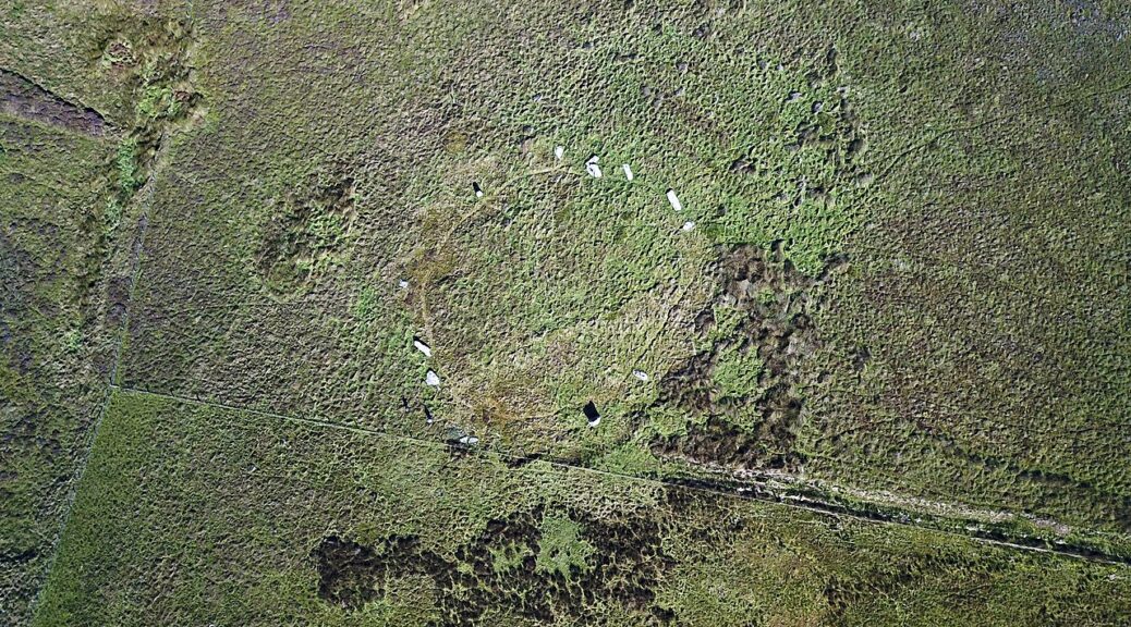
Grace went on to describe several of the standing stone sites, such as Cultoon in The Rhinns region, which has the only stone circle on the island. It has 15 stones, only 3 of which are standing. It was excavated by Euan Mackie in the 1970s. There are several empty sockets and hence the circle has been described as ‘unfinished’. This raises the question of what do we classify as unfinished? Another notable site is Ballinaby, that has two standing stones, but reports from the 18th century that say there was a third. One of the existing stones is 5m tall, which is the tallest on the island.
The stones of the 10 sites were compared and shown to be variable in height, width, shape, colour and geology. A common factor was they were all located on elevated land, were next to water (whether this be the sea or a loch) and could be seen from a long distance. The North has more standing stones than the other regions, with lower average heights. The Oa and Central Islay have the only lone stones, The Rhinns has the only stone circle, and the other regions have stone rows. The Oa and Central Islay have less stones than the other regions and with the least variety, suggesting these were the least important regions. The Rhinns has taller stones, and both a circle and a row. The North has more stones and more rows, but with lower average heights and The South has lone stones and rows, with the largest average height.
There are 50 duns and 38 chapels on the island, and Grace looked at the percentage of standing stone sites compared to the percentage of duns and chapels (mostly Medieval), by region. The standing stone distribution was more similar to the distribution of chapels than they were to the duns, suggesting a more religious purpose. One of the limitations is that chapels may have been destroyed, for instance in Central Islay that was used as farmland in the Medieval. Also, some chapels recorded in the 18th century can no longer be seen today.
The distribution of standing stone sites in the different regions suggest distinctive areas of activity. Constructing them on elevated land and close to water ensured they could be easily seen, including from approaching boats. They could have been constructed to mark territory and/or to display elitism. Being close to the sea would also have permitted easy transport of the stones.
Grace concluded by saying that for her Masters (starting October 2026) dissertation, she will be looking at landscape and the importance of water, and Neolithic shifts in diet away from seafood, that was common in the Mesolithic.
report by Debbie Cousins
image: Cultoon stone circle, Islay (Wikimedia Commons)